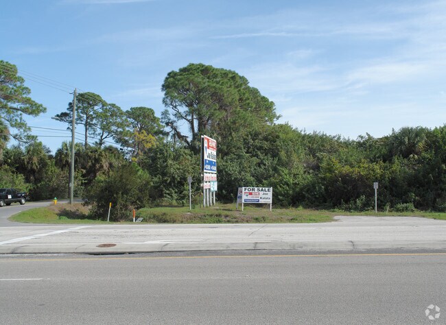
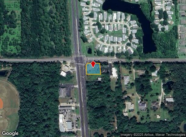
Property Record
4280 N Courtenay Pkwy, Merritt Island, FL 32953
NEARBY LISTINGS FOR SALE OR LEASE
Property Detail
4280 N Courtenay Pkwy
24-36-02-00-00251.1-0000.00
PT OF NW 1/4 OF NW 1/4 AS DESC IN ORB 496 PG 250 EXC RD R/W
Commercialacreage
Brevard
X
Florida
12009C0340H
0.44 AC
2024
Brevard County
2025
Orlando
069801
Palm Bay-Melbourne-Titusville, FL
DEMOGRAPHICS near 4280 N Courtenay Pkwy
1 Mile
3 Mile
5 Mile
2024 Total Population
3,848
11,945
44,640
2029 Population
4,185
12,977
48,599
Pop Growth 2024-2029
+ 8.76%
+ 8.64%
+ 8.87%
Average Age
49
47
45
2024 Total Households
1,599
4,909
18,962
HH Growth 2024-2029
+ 8.76%
+ 8.47%
+ 8.63%
Median Household Inc
$118,948
$104,718
$67,200
Avg Household Size
2.30
2.30
2.30
2024 Avg HH Vehicles
2.00
2.00
2.00
Median Home Value
$416,621
$402,500
$320,721
Median Year Built
1996
1992
1978
Nearby Places
Map Layers
Map Styles
 Street
 Aerial
- Restaurants
- Banks
- Shops
- Fitness
- Groceries
PUBLIC TRANSPORTATION
AIRPORT
Melbourne Orlando International
DRIVE
WALK
Distance
Melbourne Orlando International
50 min
35.0 mi
Freight Ports
Port Canaveral
DRIVE
WALK
Distance
Port Canaveral
13 min
7.9 mi
Nearby Properties
Address
Land Use
TOTAL SIZE
Lot Size
Zoning
Address
Land Use
TOTAL SIZE
Lot Size
Zoning
16,433 SF
89.08 AC
GML
Address
Land Use
TOTAL SIZE
Lot Size
Zoning
587.88 AC
Address
Land Use
TOTAL SIZE
Lot Size
Zoning
180,092 SF
38.20 AC
PIP
Address
Land Use
TOTAL SIZE
Lot Size
Zoning
105,278 SF
14.75 AC
AU
Address
Land Use
TOTAL SIZE
Lot Size
Zoning
262,753 SF
24.35 AC
PIP
Address
Land Use
TOTAL SIZE
Lot Size
Zoning
212,534 SF
14.50 AC
Address
Land Use
TOTAL SIZE
Lot Size
Zoning
6,481 SF
22.73 AC
PIP
Address
Land Use
TOTAL SIZE
Lot Size
Zoning
67,595 SF
6.62 AC
Address
Land Use
TOTAL SIZE
Lot Size
Zoning
Address
Land Use
TOTAL SIZE
Lot Size
Zoning
70,834 SF
15.33 AC
INL
Address
Land Use
TOTAL SIZE
Lot Size
Zoning
109.06 AC
EU-2
Address
Land Use
TOTAL SIZE
Lot Size
Zoning
63,106 SF
271.68 AC
INL
Address
Land Use
TOTAL SIZE
Lot Size
Zoning
46,975 SF
10.90 AC
INL
Address
Land Use
TOTAL SIZE
Lot Size
Zoning
15,320 SF
113.85 AC
AU
Address
Land Use
TOTAL SIZE
Lot Size
Zoning
87,483 SF
4.20 AC
PIP(CUP)
Address
Land Use
TOTAL SIZE
Lot Size
Zoning
53,465 SF
1.96 AC
PUD
Address
Land Use
TOTAL SIZE
Lot Size
Zoning
58,962 SF
4.01 AC
BU1
Address
Land Use
TOTAL SIZE
Lot Size
Zoning
95.81 AC
GML-H
Address
Land Use
TOTAL SIZE
Lot Size
Zoning
62,320 SF
4.82 AC
BU2
Address
Land Use
TOTAL SIZE
Lot Size
Zoning
124.60 AC
PIP
Address
Land Use
TOTAL SIZE
Lot Size
Zoning
24.27 AC
GML
Address
Land Use
TOTAL SIZE
Lot Size
Zoning
15.87 AC
BU-2
Address
Land Use
TOTAL SIZE
Lot Size
Zoning
23,332 SF
10.11 AC
IN(L)
Address
Land Use
TOTAL SIZE
Lot Size
Zoning
7,982 SF
44.34 AC
AU
Address
Land Use
TOTAL SIZE
Lot Size
Zoning
24,852 SF
1.88 AC
BU1A
Address
Land Use
TOTAL SIZE
Lot Size
Zoning
24,006 SF
150.08 AC
GML
Address
Land Use
TOTAL SIZE
Lot Size
Zoning
20,168 SF
8 AC
INL
Address
Land Use
TOTAL SIZE
Lot Size
Zoning
217.77 AC
AU
Address
Land Use
TOTAL SIZE
Lot Size
Zoning
19,049 SF
4.08 AC
SEU
Address
Land Use
TOTAL SIZE
Lot Size
Zoning
21.59 AC
AU
The World's #1 Commercial Real Estate Marketplace
Connect with us
© 2025 CoStar Group
The information above has been obtained from sources believed reliable. While we do not doubt its accuracy we have not verified it and make no guarantee, warranty or representation about it. It is your responsibility to independently confirm its accuracy and completeness. Any projections, opinions, assumptions, or estimates used are for example only and do not represent the current or future performance of the property. The value of this transaction to you depends on tax and other factors which should be evaluated by your tax, financial, and legal advisors. You and your advisors should conduct a careful, independent investigation of the property to determine to your satisfaction the suitability of the property for your needs.